Swedish National Elevation Model – Now Available Directly in windPRO
The Swedish National Elevation Model (GSD Höjddata, grid 50+ nh) is now available as an online data service for users of windPRO 3.2.
The native elevation data is stored in a 50m grid-format. This can be used directly in windPRO from the elevation grid object. If you prefer to use height contour lines, then the gridded data is seamlessly converted into contour lines in the line object. The Swedish national elevation model was produced during 2009-2017 using airborne laser scanning. Credits to Lantmäteriet for the dissemination of the GSD-Höjddata (GSD-Elevation Data).
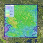
The picture shows the GSD Höjddata at a wind farm site near Oscarshamn. The background image is one of the new dynamic maps in windPRO – the windPRO European Satellite Imagery in 2.5m resolution.
Read more here:
